[Index]
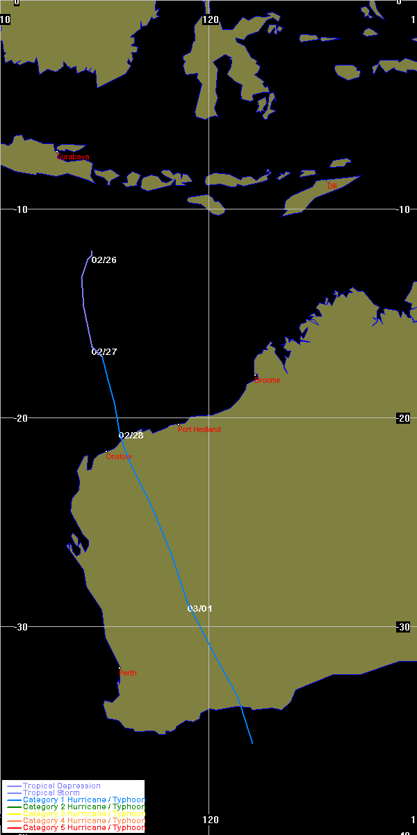
Tropical Cyclone EMMA
[Australian Region][South Indian Ocean][South Pacific Ocean]
| Tropical
Cyclones
[Index] |
Tropical Cyclone EMMA [Australian Region][South Indian Ocean][South Pacific Ocean] |
HIGH SEAS WEATHER WARNING FOR METAREA 10 ISSUED BY THE
AUSTRALIAN BUREAU OF METEOROLOGY TROPICAL CYCLONE WARNING
CENTRE PERTH AT 0125UTC 26 FEBRUARY 2006

GALE WARNING FOR THE WESTERN AREA

Please be aware, wind gusts can be a further 40 percent stronger than the
averages given here, and maximum waves may be up to twice the height.

SITUATION
At 0000UTC tropical low located within 60 nautical miles of
 Latitude thirteen decimal two degrees South [13.2S]
 Longitude one hundred and sixteen decimal zero degrees East [116.0E]
Recent movement south at 3 knots.
Maximum winds 25 knots.
Central pressure 998 hPa.

AREA AFFECTED
Within 90 nautical miles of the centre.


FORECAST
Low may develop into a tropical cyclone in the next 18 to 24 hours
causing clockwise winds 30/40 knots, rough to very rough seas and
moderate swell.


At 1200UTC 26 February: Within 80 nautical miles of
                    14.0 South 116.1 East
                    Central pressure 992 hPa.
                    Winds to 30 knots near centre.
At 0000UTC 27 February: Within 100 nautical miles of
                    15.5 South 115.6 East
                    Central pressure 986 hPa.
                    Winds to 40 knots near centre.

Next warning issued at 0700 UTC 26 February 2006.

WEATHER PERTH
=========================================================================
HIGH SEAS WEATHER WARNING FOR METAREA 10 ISSUED BY THE
AUSTRALIAN BUREAU OF METEOROLOGY TROPICAL CYCLONE WARNING
CENTRE PERTH AT 0638UTC 26 FEBRUARY 2006

GALE WARNING FOR THE WESTERN AREA

Please be aware, wind gusts can be a further 40 percent stronger than the
averages given here, and maximum waves may be up to twice the height.

SITUATION
At 0600UTC a tropical low was relocated by satellite imagery to within 60
nautical miles of
 Latitude twelve decimal three degrees South [12.3S]
 Longitude one hundred and fourteen decimal five degrees East [114.5E]
Recent movement slowly southwards.
Maximum winds 25 knots.
Central pressure 998 hPa.

AREA AFFECTED
Within 60 nautical miles of the centre, extending to within 120 nautical miles
in southern quadrants.


FORECAST
Low may develop into a tropical cyclone in the next 18 to 24 hours
causing clockwise winds 30/40 knots, rough to very rough seas and
moderate swell.


At 1800UTC 26 February: Within 80 nautical miles of
                    13.6 South 114.2 East
                    Central pressure 992 hPa.
                    Winds to 30 knots near centre.
At 0600UTC 27 February: Within 100 nautical miles of
                    15.8 South 113.7 East
                    Central pressure 986 hPa.
                    Winds to 40 knots near centre.

Next warning issued at 1300 UTC 26 February 2006.

WEATHER PERTH
=========================================================================
HIGH SEAS WEATHER WARNING FOR METAREA 10 ISSUED BY THE
AUSTRALIAN BUREAU OF METEOROLOGY TROPICAL CYCLONE WARNING
CENTRE PERTH AT 1254UTC 26 FEBRUARY 2006

STORM WARNING FOR THE WESTERN AREA

Please be aware, wind gusts can be a further 40 percent stronger than the
averages given here, and maximum waves may be up to twice the height.

SITUATION
At 1200UTC a tropical low was located within 30 nautical miles of
 Latitude twelve decimal seven degrees South [12.7S]
 Longitude one hundred and fourteen decimal two degrees East [114.2E]
Recent movement south southwest at 7 knots.
Maximum winds 30 knots.
Central pressure 997 hPa.

AREA AFFECTED
Within 60 nautical miles of the centre, extending to within 120 nautical miles
in southern quadrants.


FORECAST
Low may develop into a tropical cyclone in the next 6 to 12 hours
causing clockwise winds 30/45 knots, rough to very rough seas and
moderate swell.

Within 30 nautical miles of the centre: 45/50 knots winds with high seas and
heavy swell by 1200UTC 27 February.

At 0000UTC 27 February: Within 60 nautical miles of
                    14.5 South 113.4 East
                    Central pressure 990 hPa.
                    Winds to 35 knots near centre.
At 1200UTC 27 February: Within 90 nautical miles of
                    16.9 South 112.9 East
                    Central pressure 980 hPa.
                    Winds to 50 knots near centre.

Next warning issued at 1900 UTC 26 February 2006.

WEATHER PERTH
=========================================================================
HIGH SEAS WEATHER WARNING FOR METAREA 10 ISSUED BY THE
AUSTRALIAN BUREAU OF METEOROLOGY TROPICAL CYCLONE WARNING
CENTRE PERTH AT 1856UTC 26 FEBRUARY 2006

STORM WARNING FOR THE WESTERN AREA

Please be aware, wind gusts can be a further 40 percent stronger than the
averages given here, and maximum waves may be up to twice the height.

SITUATION
At 1800UTC a tropical low was located within 40 nautical miles of
 Latitude thirteen decimal eight degrees South [13.8S]
 Longitude one hundred and fourteen decimal one degrees East [114.1E]
Recent movement south at 8 knots.
Maximum winds 30 knots.
Central pressure 997 hPa.

AREA AFFECTED
Within 80 nautical miles of the centre.


FORECAST
Low may develop into a tropical cyclone in the next 12 hours
causing clockwise winds 30/45 knots, rough to very rough seas and
moderate swell.

Within 20 nautical miles of the centre: 45/50 knots winds with high seas and
heavy swell by 1800UTC 27 February.

At 0600UTC 27 February: Within 60 nautical miles of
                    15.6 South 113.9 East
                    Central pressure 992 hPa.
                    Winds to 35 knots near centre.
At 1800UTC 27 February: Within 80 nautical miles of
                    17.7 South 113.7 East
                    Central pressure 982 hPa.
                    Winds to 50 knots near centre.

Next warning issued at 0100 UTC 27 February 2006.

WEATHER PERTH
=========================================================================
HIGH SEAS WEATHER WARNING FOR METAREA 10 ISSUED BY THE
AUSTRALIAN BUREAU OF METEOROLOGY TROPICAL CYCLONE WARNING
CENTRE PERTH AT 0026UTC 27 FEBRUARY 2006

STORM WARNING FOR THE WESTERN AREA

Please be aware, wind gusts can be a further 40 percent stronger than the
averages given here, and maximum waves may be up to twice the height.

SITUATION
At 0000UTC a tropical low was relocated to within 50 nautical miles of
 Latitude fifteen decimal six degrees South [15.6S]
 Longitude one hundred and fifteen decimal zero degrees East [115.0E]
Recent movement south at 11 knots.
Maximum winds 30 knots.
Central pressure 996 hPa.

AREA AFFECTED
Within 90 nautical miles of the centre.


FORECAST
Low may develop into a tropical cyclone in the next 6 to 24 hours
causing clockwise winds 30/40 knots, rough to very rough seas and
moderate swell. Winds within 30 nautical miles of the centre increasing to 40/50
knots with high seas and heavy swell by 0000UTC 28 February.

At 1200UTC 27 February: Within 70 nautical miles of
                    17.5 South 115.1 East
                    Central pressure 986 hPa.
                    Winds to 40 knots near centre.
At 0000UTC 28 February: Within 90 nautical miles of
                    19.2 South 114.1 East
                    Central pressure 978 hPa.
                    Winds to 50 knots near centre.

Next warning issued at 0700 UTC 27 February 2006.

WEATHER PERTH
=========================================================================
HIGH SEAS WEATHER WARNING FOR METAREA 10 ISSUED BY THE
AUSTRALIAN BUREAU OF METEOROLOGY TROPICAL CYCLONE WARNING
CENTRE PERTH AT 0633UTC 27 FEBRUARY 2006

STORM WARNING FOR THE WESTERN AREA

Please be aware, wind gusts can be a further 40 percent stronger than the
averages given here, and maximum waves may be up to twice the height.

SITUATION
At 0600UTC a tropical low was located within 70 nautical miles of
 Latitude seventeen decimal four degrees South [17.4S]
 Longitude one hundred and fourteen decimal eight degrees East [114.8E]
Recent movement south at 13 knots.
Maximum winds 30 knots.
Central pressure 992 hPa.

AREA AFFECTED
Within 90 nautical miles of the centre, extending to within 140 nautical miles
in southern quadrants.


FORECAST
Low may develop into a tropical cyclone in the next 6 to 24 hours
causing clockwise winds 30/40 knots, rough to very rough seas and
moderate swell. Winds within 40 nautical miles of the centre increasing to 40/50
knots with high seas and heavy swell by 0600UTC 28 February.

At 1800UTC 27 February: Within 90 nautical miles of
                    19.3 South 114.4 East
                    Central pressure 986 hPa.
                    Winds to 40 knots near centre.
At 0600UTC 28 February: Within 110 nautical miles of
                    21.2 South 114.4 East
                    Central pressure 978 hPa.
                    Winds to 50 knots near centre.

Next warning issued at 1300 UTC 27 February 2006.

WEATHER PERTH
=========================================================================
HIGH SEAS WEATHER WARNING FOR METAREA 10 ISSUED BY THE
AUSTRALIAN BUREAU OF METEOROLOGY TROPICAL CYCLONE WARNING
CENTRE PERTH AT 1323UTC 27 FEBRUARY 2006

STORM WARNING FOR THE WESTERN AREA

Please be aware, wind gusts can be a further 40 percent stronger than the
averages given here, and maximum waves may be up to twice the height.

SITUATION
At 1200UTC Tropical Cyclone Emma was located within 70 nautical miles of
 Latitude eighteen decimal nine degrees South [18.9S]
 Longitude one hundred and fourteen decimal seven degrees East [114.7E]
Recent movement south at 13 knots.
Maximum winds 35 knots.
Central pressure 988 hPa.

AREA AFFECTED
Within 90 nautical miles of the centre, extending to within 140 nautical miles
in southern quadrants.


FORECAST
Clockwise winds 30/45 knots, rough to very rough seas and
moderate swell. Winds within 25 nautical miles of the centre increasing to 40/50
knots with high seas and heavy swell by 0000UTC 28 February.

At 0000UTC 28 February: Within 90 nautical miles of
                    21.2 South 114.6 East
                    Central pressure 980 hPa.
                    Winds to 50 knots near centre. [ corrected ]
At 1200UTC 28 February: Within 110 nautical miles of
                    23.7 South 114.9 East
                    Central pressure 988 hPa.
                    Winds to 35 knots near centre.
Next warning issued at 1900 UTC 27 February 2006.

WEATHER PERTH
=========================================================================
HIGH SEAS WEATHER WARNING FOR METAREA 10 ISSUED BY THE
AUSTRALIAN BUREAU OF METEOROLOGY TROPICAL CYCLONE WARNING
CENTRE PERTH AT 1605UTC 27 FEBRUARY 2006

STORM WARNING FOR THE WESTERN AREA

Please be aware, wind gusts can be a further 40 percent stronger than the
averages given here, and maximum waves may be up to twice the height.

SITUATION
At 1500UTC Tropical Cyclone Emma was located within 45 nautical miles of
 Latitude nineteen decimal four degrees South [19.4S]
 Longitude one hundred and fourteen decimal nine degrees East [114.9E]
Recent movement south at 12 knots.
Maximum winds 40 knots.
Central pressure 986 hPa.

AREA AFFECTED
Within 90 nautical miles of the centre, extending to within 120 nautical miles
in eastern quadrants.


FORECAST
Clockwise winds 30/45 knots, rough to very rough seas and
moderate swell. Winds within 25 nautical miles of the centre increasing to 40/50
knots with high seas and heavy swell by 0000UTC 28 February.

At 0000UTC 28 February: Within 55 nautical miles of
                    21.2 South 114.6 East
                    Central pressure 980 hPa.
                    Winds to 50 knots near centre.
At 1200UTC 28 February: Within 65 nautical miles of
                    23.7 South 114.9 East
                    Central pressure 988 hPa.
                    Winds to 35 knots near centre.
Next warning issued at 1900 UTC 27 February 2006.

WEATHER PERTH
=========================================================================
HIGH SEAS WEATHER WARNING FOR METAREA 10 ISSUED BY THE
AUSTRALIAN BUREAU OF METEOROLOGY TROPICAL CYCLONE WARNING
CENTRE PERTH AT 1858UTC 27 FEBRUARY 2006

STORM WARNING FOR THE WESTERN AREA

Please be aware, wind gusts can be a further 40 percent stronger than the
averages given here, and maximum waves may be up to twice the height.

SITUATION
At 1800UTC Tropical Cyclone Emma was located within 50 nautical miles of
 Latitude nineteen decimal five degrees South [19.5S]
 Longitude one hundred and fifteen decimal seven degrees East [115.7E]
Recent movement south southeast at 12 knots.
Maximum winds 40 knots.
Central pressure 986 hPa.

AREA AFFECTED
Within 100 nautical miles of the centre, extending to within 120 nautical miles
in eastern quadrants.


FORECAST
Clockwise winds 30/45 knots, rough to very rough seas and
moderate swell. Winds within 25 nautical miles of the centre increasing to 40/50
knots with high seas and heavy swell by 0000UTC 28 February.

At 0600UTC 28 February: Inland, within 70 nautical miles of
                    21.6 South 116.2 East
                    Central pressure 986 hPa.
                    Winds to 45 knots near centre.
At 1800UTC 28 February: Well inland, within 80 nautical miles of
                    23.8 South 116.8 East
                    Central pressure 995 hPa.
                    Winds to 35 knots near centre.
Next warning issued at 0100 UTC 28 February 2006.

WEATHER PERTH
=========================================================================
HIGH SEAS WEATHER WARNING FOR METAREA 10 ISSUED BY THE
AUSTRALIAN BUREAU OF METEOROLOGY TROPICAL CYCLONE WARNING
CENTRE PERTH AT 0110UTC 28 FEBRUARY 2006

GALE WARNING FOR THE WESTERN AREA

Please be aware, wind gusts can be a further 40 percent stronger than the
averages given here, and maximum waves may be up to twice the height.

SITUATION
At 0000UTC Tropical Cyclone Emma was located within 30 nautical miles of
 Latitude twenty decimal six degrees South [20.6S]
 Longitude one hundred and fifteen decimal six degrees East [115.6E]
Recent movement south at 12 knots.
Maximum winds 40 knots.
Central pressure 986 hPa.

AREA AFFECTED
Within 60 nautical miles of the centre, extending to within 120 nautical miles
in eastern quadrants.


FORECAST
Clockwise winds 30/40 knots, rough to very rough seas,
moderate swell. Winds expected to ease below 34 knots by 0600UTC 28 February.

At 1200UTC 28 February: Inland, within 60 nautical miles of
                    23.2 South 116.1 East
                    Central pressure 996 hPa.
                    Winds to 30 knots near centre.
Next warning issued at 0700 UTC 28 February 2006.

WEATHER PERTH
=========================================================================
HIGH SEAS WEATHER WARNING FOR METAREA 10 ISSUED BY THE
AUSTRALIAN BUREAU OF METEOROLOGY TROPICAL CYCLONE WARNING
CENTRE PERTH AT 0642UTC 28 FEBRUARY 2006
CANCELLATION OF
GALE WARNING FOR THE WESTERN AREA

Please be aware, wind gusts can be a further 40 percent stronger than the
averages given here, and maximum waves may be up to twice the height.

SITUATION
At 0600UTC Ex-Tropical Cyclone Emma was located over land, within 20 nautical
miles of
 Latitude twenty two decimal zero degrees South [22.0S]
 Longitude one hundred and sixteen decimal three degrees East [116.3E]
Recent movement south southeast at 15 knots.
Maximum winds 30 knots.
Central pressure 992 hPa.


AREA AFFECTED
Nil.


FORECAST
Winds have eased below 34 knots.

No further warnings will be issued for this system.

WEATHER PERTH
=========================================================================
|
Document: emma.htm
Updated: 1st March 2006 |
[Australian Severe Weather index] [Copyright Notice] [Email Contacts] [Search This Site] |