[Index]
Tropical Cyclone GLENDA
[Australian Region][South Indian Ocean][South Pacific Ocean]
| Tropical
Cyclones
[Index] |
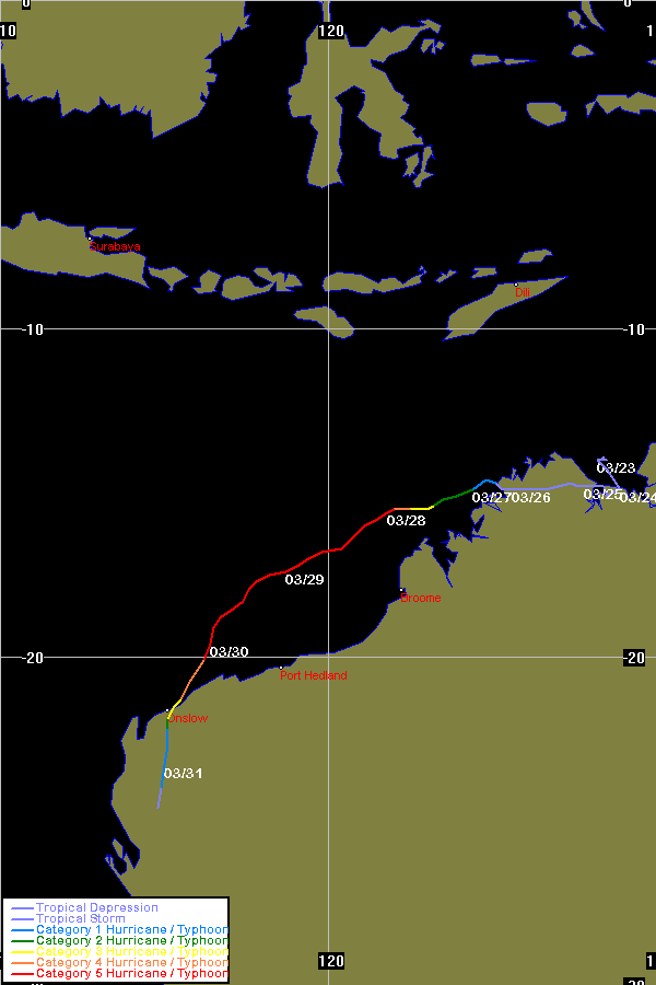
Tropical Cyclone GLENDA [Australian Region][South Indian Ocean][South Pacific Ocean] |
HIGH SEAS WEATHER WARNING FOR METAREA 10 ISSUED BY THE
AUSTRALIAN BUREAU OF METEOROLOGY TROPICAL CYCLONE WARNING
CENTRE PERTH AT 0034UTC 27 MARCH 2006

STORM WARNING FOR THE WESTERN AREA

Please be aware, wind gusts can be a further 40 percent stronger than the
averages given here, and maximum waves may be up to twice the height.

SITUATION
At 0000UTC developing tropical low located within 20 nautical miles of
Latitude fifteen decimal one degrees South [15.1S]
Longitude one hundred and twenty four decimal three degrees East [124.3E]
Recent movement  : West at 4 knots.
Maximum winds    : 30 knots.
Central pressure : 994hPa.

The low is expected to develop into a tropical cyclone in the next 6 to 12
hours.


AREA AFFECTED
Within 60 nautical miles of the centre.


FORECAST
Sustained winds near the centre increasing to 40 knots by 1200UTC 27 March and
to 50 knots by 0000UTC 28 March.
Within 25 nautical miles of centre winds above 48 knots by 0000UTC 28 March with
high seas and moderate increasing swell.
Within 60 nautical miles of centre winds above 35 knots by 1200UTC 27 March with
very rough seas and moderate increasing swell.


At 1200UTC 27 March: Within 40 nautical miles of 15.3 South 123.6 East
                     Central pressure 988hPa.
                     Winds to 40 knots near centre.
At 0000UTC 28 March: Within 70 nautical miles of 15.8 South 122.2 East
                     Central pressure 980hPa.
                     Winds to 50 knots near centre.

Next warning issued by 0700UTC 27 March 2006
=========================================================================
HIGH SEAS WEATHER WARNING FOR METAREA 10 ISSUED BY THE
AUSTRALIAN BUREAU OF METEOROLOGY TROPICAL CYCLONE WARNING
CENTRE PERTH AT 0354UTC 27 MARCH 2006
UPDATED
STORM WARNING FOR THE WESTERN AREA

Please be aware, wind gusts can be a further 40 percent stronger than the
averages given here, and maximum waves may be up to twice the height.

SITUATION
At 0300UTC Tropical Cyclone Glenda located within 20 nautical miles of
Latitude fifteen decimal zero degrees South [15.0S]
Longitude one hundred and twenty three decimal nine degrees East [123.9E]
Recent movement  : West at 5 knots.
Maximum winds    : 35 knots.
Central pressure : 990hPa.


AREA AFFECTED
Within 35 nautical miles of the centre, extending to within 70 nautical miles of
the centre by 0300UTC 28 March.


FORECAST
Sustained winds near the centre increasing to 40 knots by 1200UTC 27 March and
to 50 knots by 0000UTC 28 March.
Within 25 nautical miles of centre winds above 48 knots by 0000UTC 28 March with
high seas and moderate increasing swell.
Within 35 nautical miles of centre, extending to within 70 nautical miles of the
centre by 0300UTC 28 March, winds above 35 knots with very rough seas and
moderate increasing swell.


At 1200UTC 27 March: Within 40 nautical miles of 15.3 South 123.6 East
                     Central pressure 986hPa.
                     Winds to 40 knots near centre.
At 0000UTC 28 March: Within 70 nautical miles of 15.8 South 122.2 East
                     Central pressure 980hPa.
                     Winds to 50 knots near centre.
This warning updated to indicate the system has reached cyclone intensity.
Next warning issued by 0700UTC 27 March 2006
=========================================================================
HIGH SEAS WEATHER WARNING FOR METAREA 10 ISSUED BY THE
AUSTRALIAN BUREAU OF METEOROLOGY TROPICAL CYCLONE WARNING
CENTRE PERTH AT 0654UTC 27 MARCH 2006

HURRICANE WARNING FOR THE WESTERN AREA

Please be aware, wind gusts can be a further 40 percent stronger than the
averages given here, and maximum waves may be up to twice the height.

SITUATION
At 0600UTC Tropical Cyclone Glenda located within 20 nautical miles of
Latitude fifteen decimal two degrees South [15.2S]
Longitude one hundred and twenty three decimal five degrees East [123.5E]
Recent movement  : West at 7 knots.
Maximum winds    : 50 knots.
Central pressure : 980hPa.


AREA AFFECTED
Within 45 nautical miles of the centre, extending to within 65 nautical miles of
the centre by 0600UTC 28 March.


FORECAST
Sustained winds near the centre to 50 knots, increasing to 70 knots by 0600UTC
28 March.
Within 20 nautical miles of centre increasing to within 25nm of centre by
0600UTC 28 March, clockwise winds above 48 knots, high seas and moderate
increasing swell.
Within 45 nautical miles of centre, extending to within 65 nautical miles of the
centre by 0600UTC 28 March, winds above 35 knots with very rough seas and
moderate increasing swell.


At 1800UTC 27 March: Within 45 nautical miles of 15.6 South 122.2 East
                     Central pressure 970hPa.
                     Winds to 60 knots near centre.
At 0600UTC 28 March: Within 70 nautical miles of 16.8 South 120.9 East
                     Central pressure 962hPa.
                     Winds to 70 knots near centre.

Next warning issued by 1300UTC 27 March 2006
=========================================================================
HIGH SEAS WEATHER WARNING FOR METAREA 10 ISSUED BY THE
AUSTRALIAN BUREAU OF METEOROLOGY TROPICAL CYCLONE WARNING
CENTRE PERTH AT 1301UTC 27 MARCH 2006

HURRICANE WARNING FOR THE WESTERN AREA

Please be aware, wind gusts can be a further 40 percent stronger than the
averages given here, and maximum waves may be up to twice the height.

SITUATION
At 1200UTC Severe Tropical Cyclone Glenda located within 20 nautical miles of
Latitude fifteen decimal four degrees South [15.4S]
Longitude one hundred and twenty three decimal zero degrees East [123.0E]
Recent movement  : West southwest at 5 knots.
Maximum winds    : 65 knots.
Central pressure : 970hPa.


AREA AFFECTED
Within 50 nautical miles of the centre, extending to within 80 nautical miles of
the centre by 1200UTC 28 March.


FORECAST
Sustained winds near the centre to 65 knots, increasing to 90 knots by 1200UTC
28 March.
Within 20 nautical miles of centre increasing to within 25nm of centre by
0600UTC 28 March, clockwise winds above 48 knots, high seas and moderate
increasing swell.
Within 50 nautical miles of centre, extending to within 80 nautical miles of the
centre by 1200UTC 28 March, winds above 35 knots with very rough seas and
moderate increasing swell.


At 0000UTC 28 March: Within 45 nautical miles of 15.8 South 121.7 East
                     Central pressure 950hPa.
                     Winds to 80 knots near centre.
At 1200UTC 28 March: Within 70 nautical miles of 16.7 South 120.5 East
                     Central pressure 940hPa.
                     Winds to 90 knots near centre.

Next warning issued by 1900UTC 27 March 2006
=========================================================================
HIGH SEAS WEATHER WARNING FOR METAREA 10 ISSUED BY THE
AUSTRALIAN BUREAU OF METEOROLOGY TROPICAL CYCLONE WARNING
CENTRE PERTH AT 1840UTC 27 MARCH 2006

HURRICANE WARNING FOR THE WESTERN AREA

Please be aware, wind gusts can be a further 40 percent stronger than the
averages given here, and maximum waves may be up to twice the height.

SITUATION
At 1800UTC Severe Tropical Cyclone Glenda located within 20 nautical miles of
Latitude fifteen decimal six degrees South [15.6S]
Longitude one hundred and twenty two decimal two degrees East [122.2E]
Recent movement  : West southwest at 8 knots.
Maximum winds    : 70 knots.
Central pressure : 965hPa.


AREA AFFECTED
Within 60 nautical miles of the centre, extending to within 80 nautical miles of
the centre by 1800UTC 28 March.


FORECAST
Sustained winds near the centre to 70 knots, increasing to 100 knots by 1800UTC
28 March.
Within 20 nautical miles of centre increasing to within 30nm of centre by
1800UTC 28 March, clockwise winds above 48 knots, high seas and moderate
increasing swell.
Within 60 nautical miles of centre, extending to within 80 nautical miles of the
centre by 1800UTC 28 March, winds above 35 knots with very rough seas and heavy
swell.


At 0600UTC 28 March: Within 40 nautical miles of 16.4 South 120.5 East
                     Central pressure 945hPa.
                     Winds to 85 knots near centre.
At 1800UTC 28 March: Within 70 nautical miles of 16.9 South 119.0 East
                     Central pressure 930hPa.
                     Winds to 100 knots near centre.

Next warning issued by 0100UTC 28 March 2006
=========================================================================
HIGH SEAS WEATHER WARNING FOR METAREA 10 ISSUED BY THE
AUSTRALIAN BUREAU OF METEOROLOGY TROPICAL CYCLONE WARNING
CENTRE PERTH AT 0059UTC 28 MARCH 2006

HURRICANE WARNING FOR THE WESTERN AREA

Please be aware, wind gusts can be a further 40 percent stronger than the
averages given here, and maximum waves may be up to twice the height.

SITUATION
At 0000UTC Severe Tropical Cyclone Glenda located within 20 nautical miles of
Latitude fifteen decimal six degrees South [15.6S]
Longitude one hundred and twenty one decimal six degrees East [121.6E]
Recent movement  : West southwest at 6 knots.
Maximum winds    : 80 knots.
Central pressure : 955hPa.


AREA AFFECTED
Within 75 nautical miles of the centre, extending to within 90 nautical miles of
the centre by 0000UTC 29 March.


FORECAST
Sustained winds near the centre to 80 knots, increasing to 105 knots by 0000UTC
29 March.
Within 15 nautical miles of centre increasing to within 20nm of centre by
0000UTC 29 March, clockwise winds above 64 knots, phenomenal seas and heavy
swell.
Within 30 nautical miles of centre increasing to within 40nm of centre by
0000UTC 29 March, clockwise winds above 48 knots, very high seas and heavy
swell.
Within 75 nautical miles of centre, extending to within 90 nautical miles of the
centre by 0000UTC 29 March, winds above 35 knots with very rough seas and heavy
swell.


At 1200UTC 28 March: Within 40 nautical miles of 16.2 South 120.3 East
                     Central pressure 935hPa.
                     Winds to 90 knots near centre.
At 0000UTC 29 March: Within 60 nautical miles of 17.0 South 118.8 East
                     Central pressure 915hPa.
                     Winds to 105 knots near centre.

Next warning issued by 0700UTC 28 March 2006.
=========================================================================
HIGH SEAS WEATHER WARNING FOR METAREA 10 ISSUED BY THE
AUSTRALIAN BUREAU OF METEOROLOGY TROPICAL CYCLONE WARNING
CENTRE PERTH AT 0700UTC 28 MARCH 2006

HURRICANE WARNING FOR THE WESTERN AREA

Please be aware, wind gusts can be a further 40 percent stronger than the
averages given here, and maximum waves may be up to twice the height.

SITUATION
At 0600UTC Severe Tropical Cyclone Glenda located within 20 nautical miles of
Latitude sixteen decimal zero degrees South [16.0S]
Longitude one hundred and twenty one decimal one degrees East [121.1E]
Recent movement  : West southwest at 6 knots.
Maximum winds    : 100 knots.
Central pressure : 925hPa.


AREA AFFECTED
Within 60 nautical miles of the centre, extending to within 80 nautical miles of
the centre by 0600UTC 29 March.


FORECAST
Sustained winds near the centre to 100 knots, increasing to 120 knots by 0600UTC
29 March.
Within 20 nautical miles of centre, clockwise winds above 64 knots, phenomenal
seas and heavy swell.
Within 30 nautical miles of centre increasing to within 40nm of centre by
0600UTC 29 March, clockwise winds above 48 knots, very high seas and heavy
swell.
Within 60 nautical miles of centre, extending to within 80 nautical miles of the
centre by 0600UTC 29 March, winds above 35 knots with very rough seas and heavy
swell.


At 1800UTC 28 March: Within 40 nautical miles of 16.6 South 119.6 East
                     Central pressure 915hPa.
                     Winds to 110 knots near centre.
At 0600UTC 29 March: Within 60 nautical miles of 17.5 South 118.1 East
                     Central pressure 905hPa.
                     Winds to 120 knots near centre.

Next warning issued by 1300UTC 28 March 2006.
=========================================================================
HIGH SEAS WEATHER WARNING FOR METAREA 10 ISSUED BY THE
AUSTRALIAN BUREAU OF METEOROLOGY TROPICAL CYCLONE WARNING
CENTRE PERTH AT 1342UTC 28 MARCH 2006

HURRICANE WARNING FOR THE WESTERN AREA

Please be aware, wind gusts can be a further 40 percent stronger than the
averages given here, and maximum waves may be up to twice the height.

SITUATION
At 1200UTC Severe Tropical Cyclone Glenda located within 15 nautical miles of
Latitude sixteen decimal seven degrees South [16.7S]
Longitude one hundred and twenty decimal four degrees East [120.4E]
Recent movement  : Southwest at 10 knots.
Maximum winds    : 115 knots.
Central pressure : 910hPa.


AREA AFFECTED
Within 60 nautical miles of the centre, extending to within 80 nautical miles of
the centre by 1200UTC 29 March.


FORECAST
Sustained winds near the centre to 120 knots.
Within 20 nautical miles of centre, clockwise winds above 64 knots, phenomenal
seas and heavy swell.
Within 30 nautical miles of centre, clockwise winds above 48 knots, very high
seas and heavy swell.
Within 60 nautical miles of centre, extending to within 80 nautical miles of the
centre by 1200UTC 29 March, winds above 35 knots with very rough seas and heavy
swell.


At 0000UTC 29 March: Within 35 nautical miles of 17.9 South 118.9 East
                     Central pressure 905hPa.
                     Winds to 120 knots near centre.
At 1200UTC 29 March: Within 60 nautical miles of 18.9 South 117.4 East
                     Central pressure 905hPa.
                     Winds to 120 knots near centre.

Next warning issued by 1900UTC 28 March 2006.
=========================================================================
HIGH SEAS WEATHER WARNING FOR METAREA 10 ISSUED BY THE
AUSTRALIAN BUREAU OF METEOROLOGY TROPICAL CYCLONE WARNING
CENTRE PERTH AT 1855UTC 28 MARCH 2006

HURRICANE WARNING FOR THE WESTERN AREA

Please be aware, wind gusts can be a further 40 percent stronger than the
averages given here, and maximum waves may be up to twice the height.

SITUATION
At 1800UTC Severe Tropical Cyclone Glenda located within 15 nautical miles of
Latitude seventeen decimal zero degrees South [17.0S]
Longitude one hundred and nineteen decimal five degrees East [119.5E]
Recent movement  : West southwest at 9 knots.
Maximum winds    : 115 knots.
Central pressure : 910hPa.


AREA AFFECTED
Within 60 nautical miles of the centre, extending to within 80 nautical miles of
the centre by 1800UTC 29 March.


FORECAST
Sustained winds near the centre to 115 knots.
Within 20 nautical miles of centre, clockwise winds above 64 knots, phenomenal
seas and heavy swell.
Within 30 nautical miles of centre, clockwise winds above 48 knots, very high
seas and heavy swell.
Within 60 nautical miles of centre, extending to within 80 nautical miles of the
centre by 1800UTC 29 March, winds above 35 knots with very rough seas and heavy
swell.


At 0600UTC 29 March: Within 35 nautical miles of 18.0 South 117.9 East
                     Central pressure 910hPa.
                     Winds to 115 knots near centre.
At 1800UTC 29 March: Within 60 nautical miles of 19.0 South 116.8 East
                     Central pressure 910hPa.
                     Winds to 115 knots near centre.

Next warning issued by 0100UTC 29 March 2006.
=========================================================================
HIGH SEAS WEATHER WARNING FOR METAREA 10 ISSUED BY THE
AUSTRALIAN BUREAU OF METEOROLOGY TROPICAL CYCLONE WARNING
CENTRE PERTH AT 0051UTC 29 MARCH 2006

HURRICANE WARNING FOR THE WESTERN AREA

Please be aware, wind gusts can be a further 40 percent stronger than the
averages given here, and maximum waves may be up to twice the height.

SITUATION
At 0000UTC Severe Tropical Cyclone Glenda located within 15 nautical miles of
Latitude seventeen decimal three degrees South [17.3S]
Longitude one hundred and eighteen decimal eight degrees East [118.8E]
Recent movement  : West southwest at 6 knots.
Maximum winds    : 110 knots.
Central pressure : 910hPa.


AREA AFFECTED
Within 80 nautical miles of the centre.


FORECAST
Sustained winds near the centre to 110 knots.
Within 15 nautical miles of centre, clockwise winds above 64 knots, phenomenal
seas and heavy swell.
Within 35 nautical miles of centre, clockwise winds above 48 knots, very high
seas and heavy swell.
Within 80 nautical miles of centre, winds above 35 knots with very rough seas
and heavy swell.


At 1200UTC 29 March: Within 40 nautical miles of 18.5 South 117.6 East
                     Central pressure 922hPa.
                     Winds to 100 knots near centre.
At 0000UTC 30 March: Within 60 nautical miles of 19.8 South 116.4 East
                     Central pressure 922hPa.
                     Winds to 100 knots near centre.

Next warning issued by 0700UTC 29 March 2006.
=========================================================================
HIGH SEAS WEATHER WARNING FOR METAREA 10 ISSUED BY THE
AUSTRALIAN BUREAU OF METEOROLOGY TROPICAL CYCLONE WARNING
CENTRE PERTH AT 0355UTC 29 MARCH 2006

HURRICANE WARNING FOR THE WESTERN AREA

Please be aware, wind gusts can be a further 40 percent stronger than the
averages given here, and maximum waves may be up to twice the height.

SITUATION
At 0300UTC Severe Tropical Cyclone Glenda located within 15 nautical miles of
Latitude seventeen decimal five degrees South [17.5S]
Longitude one hundred and eighteen decimal four degrees East [118.4E]
Recent movement  : West southwest at 7 knots.
Maximum winds    : 105 knots.
Central pressure : 916hPa.


AREA AFFECTED
Within 80 nautical miles of the centre in northern quadrants, extending to
within 140 nautical miles of centre in southern quadrants.


FORECAST
Sustained winds near the centre to 105 knots.
Within 20 nautical miles of centre, clockwise winds above 64 knots, phenomenal
seas and heavy swell.
Within 45 nautical miles of centre, clockwise winds above 48 knots, very high
seas and heavy swell.
Within 80 nautical miles of centre in northern quadrants, extending to within
140 nautical miles of centre in southern quadrants, winds above 33 knots with
very rough seas and heavy swell.


At 1200UTC 29 March: Within 40 nautical miles of 18.5 South 117.6 East
                     Central pressure 922hPa.
                     Winds to 100 knots near centre.
At 0000UTC 30 March: Within 60 nautical miles of 19.8 South 116.4 East
                     Central pressure 922hPa.
                     Winds to 100 knots near centre.

Next warning issued by 0700UTC 29 March 2006.
=========================================================================
HIGH SEAS WEATHER WARNING FOR METAREA 10 ISSUED BY THE
AUSTRALIAN BUREAU OF METEOROLOGY TROPICAL CYCLONE WARNING
CENTRE PERTH AT 0658UTC 29 MARCH 2006

HURRICANE WARNING FOR THE WESTERN AREA

Please be aware, wind gusts can be a further 40 percent stronger than the
averages given here, and maximum waves may be up to twice the height.

SITUATION
At 0600UTC Severe Tropical Cyclone Glenda located within 15 nautical miles of
Latitude seventeen decimal seven degrees South [17.7S]
Longitude one hundred and eighteen decimal zero degrees East [118.0E]
Recent movement  : West southwest at 7 knots.
Maximum winds    : 100 knots.
Central pressure : 920hPa.


AREA AFFECTED
Within 80 nautical miles of the centre in northern quadrants, extending to
within 140 nautical miles of centre in southern quadrants.


FORECAST
Sustained winds near the centre to 100 knots.
Within 20 nautical miles of centre, clockwise winds above 64 knots, phenomenal
seas and heavy swell.
Within 45 nautical miles of centre, clockwise winds above 48 knots, very high
seas and heavy swell.
Within 80 nautical miles of centre in northern quadrants, extending to within
140 nautical miles of centre in southern quadrants, winds above 33 knots with
very rough seas and heavy swell.


At 1800UTC 29 March: Within 40 nautical miles of 18.9 South 116.7 East
                     Central pressure 920hPa.
                     Winds to 100 knots near centre.
At 0600UTC 30 March: Within 60 nautical miles of 20.6 South 115.8 East
                     Central pressure 920hPa.
                     Winds to 100 knots near centre.

Next warning issued by 1300UTC 29 March 2006.
=========================================================================
HIGH SEAS WEATHER WARNING FOR METAREA 10 ISSUED BY THE
AUSTRALIAN BUREAU OF METEOROLOGY TROPICAL CYCLONE WARNING
CENTRE PERTH AT 1242UTC 29 MARCH 2006

HURRICANE WARNING FOR THE WESTERN AREA

Please be aware, wind gusts can be a further 40 percent stronger than the
averages given here, and maximum waves may be up to twice the height.

SITUATION
At 1200UTC Severe Tropical Cyclone Glenda located within 20 nautical miles of
Latitude eighteen decimal three degrees South [18.3S]
Longitude one hundred and seventeen decimal five degrees East [117.5E]
Recent movement  : West southwest at 7 knots.
Maximum winds    : 100 knots.
Central pressure : 920hPa.


AREA AFFECTED
Within 110 nautical miles of the centre in northwest quadrants, extending to
within 130 nautical miles of centre in southeast quadrants.


FORECAST
Sustained winds near the centre to 100 knots.
Within 30 nautical miles of centre, clockwise winds above 64 knots, phenomenal
seas and heavy swell.
Within 50 nautical miles of centre, clockwise winds above 48 knots, very high
seas and heavy swell.
Within 110 nautical miles of centre in northwest quadrants, extending to within
130 nautical miles of centre in southeast quadrants, winds above 33 knots with
very rough seas and heavy swell.


At 0000UTC 30 March: Within 40 nautical miles of 19.7 South 116.4 East
                     Central pressure 920hPa.
                     Winds to 100 knots near centre.
At 1200UTC 30 March: Within 60 nautical miles of 21.3 South 115.5 East
                     Central pressure 920hPa.
                     Winds to 100 knots near centre.

Next warning issued by 1900UTC 29 March 2006.
=========================================================================
HIGH SEAS WEATHER WARNING FOR METAREA 10 ISSUED BY THE
AUSTRALIAN BUREAU OF METEOROLOGY TROPICAL CYCLONE WARNING
CENTRE PERTH AT 1900UTC 29 MARCH 2006

HURRICANE WARNING FOR THE WESTERN AREA

Please be aware, wind gusts can be a further 40 percent stronger than the
averages given here, and maximum waves may be up to twice the height.

SITUATION
At 1800UTC Severe Tropical Cyclone Glenda located within 20 nautical miles of
Latitude eighteen decimal eight degrees South [18.8S]
Longitude one hundred and sixteen decimal seven degrees East [116.7E]
Recent movement  : West southwest at 9 knots.
Maximum winds    : 100 knots.
Central pressure : 925hPa.


AREA AFFECTED
Within 140 nautical miles of the centre.


FORECAST
Sustained winds near the centre to 100 knots.
Within 30 nautical miles of centre, clockwise winds above 64 knots, phenomenal
seas and heavy swell.
Within 50 nautical miles of centre, clockwise winds above 48 knots, very high
seas and heavy swell.
Within 120 nautical miles of centre in northeast quadrants, extending to within
140 nautical miles of centre in southwest quadrants, winds above 33 knots with
very rough seas and heavy swell.


At 0600UTC 30 March: Within 40 nautical miles of 20.3 South 115.7 East
                     Central pressure 925hPa.
                     Winds to 100 knots near centre.
At 1800UTC 30 March: Within 60 nautical miles of 22.0 South 114.9 East
                     Central pressure 940hPa.
                     Winds to 90 knots near centre.

Next warning issued by 0100UTC 30 March 2006.
=========================================================================
HIGH SEAS WEATHER WARNING FOR METAREA 10 ISSUED BY THE
AUSTRALIAN BUREAU OF METEOROLOGY TROPICAL CYCLONE WARNING
CENTRE PERTH AT 0051UTC 30 MARCH 2006
CORRECTED
HURRICANE WARNING FOR THE WESTERN AREA

Please be aware, wind gusts can be a further 40 percent stronger than the
averages given here, and maximum waves may be up to twice the height.

SITUATION
At 0000UTC Severe Tropical Cyclone Glenda located within 15 nautical miles of
Latitude nineteen decimal five degrees South [19.5S]
Longitude one hundred and sixteen decimal five degrees East [116.5E]
Recent movement  : South southwest at 7 knots.
Maximum winds    : 90 knots.
Central pressure : 936hPa.
Warning reissued to correct error in latitude.


AREA AFFECTED
Within 140 nautical miles of the centre.


FORECAST
Sustained winds near the centre to 90 knots.
Within 30 nautical miles of centre, clockwise winds above 64 knots, phenomenal
seas and heavy swell.
Within 60 nautical miles of centre, clockwise winds above 48 knots, very high
seas and heavy swell.
Within 120 nautical miles of centre in northern quadrants, extending to within
140 nautical miles of centre in southern quadrants, winds above 33 knots with
very rough seas and heavy swell.


At 1200UTC 30 March: Within 40 nautical miles of 21.3 South 115.7 East
                     Central pressure 936hPa.
                     Winds to 90 knots near centre.
At 0000UTC 31 March: Within 60 nautical miles of 23.0 South 114.8 East
                     Central pressure 970hPa.
                     Winds to 60 knots near centre.

Next warning issued by 0700UTC 30 March 2006.
=========================================================================
HIGH SEAS WEATHER WARNING FOR METAREA 10 ISSUED BY THE
AUSTRALIAN BUREAU OF METEOROLOGY TROPICAL CYCLONE WARNING
CENTRE PERTH AT 0644UTC 30 MARCH 2006

HURRICANE WARNING FOR THE WESTERN AREA

Please be aware, wind gusts can be a further 40 percent stronger than the
averages given here, and maximum waves may be up to twice the height.

SITUATION
At 0600UTC Severe Tropical Cyclone Glenda located within 15 nautical miles of
Latitude twenty decimal seven degrees South [20.7S]
Longitude one hundred and fifteen decimal eight degrees East [115.8E]
Recent movement  : south southwest at 13 knots.
Maximum winds    : 95 knots.
Central pressure : 930hPa.


AREA AFFECTED
Within 120 nautical miles of the centre.


FORECAST
Sustained winds near the centre to 95 knots, easing from 1200UTC 30 March 2006
as the system moves inland.
Within 30 nautical miles of centre, clockwise winds above 64 knots, phenomenal
seas and heavy swell.
Within 60 nautical miles of centre, clockwise winds above 48 knots, very high
seas and heavy swell.
Within 120 nautical miles of centre, winds above 33 knots with very rough seas
and heavy swell.


At 1800UTC 30 March: Inland within 40 nautical miles of
                     22.9 South 114.9 East
                     Central pressure 962hPa.
                     Winds to 70 knots near centre.
At 0600UTC 31 March: Within 60 nautical miles of 25.3 South 114.4 East
                     Central pressure 984hPa.
                     Winds to 45 knots near centre.

Next warning issued by 1300UTC 30 March 2006.
=========================================================================
HIGH SEAS WEATHER WARNING FOR METAREA 10 ISSUED BY THE
AUSTRALIAN BUREAU OF METEOROLOGY TROPICAL CYCLONE WARNING
CENTRE PERTH AT 1323UTC 30 MARCH 2006

HURRICANE WARNING FOR THE WESTERN AREA

Please be aware, wind gusts can be a further 40 percent stronger than the
averages given here, and maximum waves may be up to twice the height.

SITUATION
At 1200UTC Severe Tropical Cyclone Glenda located within 15 nautical miles of
Latitude twenty one decimal seven degrees South [21.7S]
Longitude one hundred and fifteen decimal two degrees East [115.2E]
Recent movement  : south southwest at 10 knots.
Maximum winds    : 90 knots.
Central pressure : 940hPa.


AREA AFFECTED
Within 75 nautical miles of the centre.


FORECAST
Sustained winds near the centre to 90 knots, easing to 45 knots by 1200UTC 31
March 2006 as the system moves inland.
Within 20 nautical miles of centre, clockwise winds above 64 knots, phenomenal
seas and heavy swell.
Within 35 nautical miles of centre, clockwise winds above 48 knots, very high
seas and heavy swell.
Within 75 nautical miles of centre, winds above 33 knots with very rough seas
and heavy swell.


At 0000UTC 31 March: Inland within 40 nautical miles of
                     23.6 South 114.5 East
                     Central pressure 970hPa.
                     Winds to 60 knots near centre.
At 1200UTC 31 March: Within 60 nautical miles of 26.3 South 114.6 East
                     Central pressure 980hPa.
                     Winds to 45 knots near centre.

Next warning issued by 1900UTC 30 March 2006.
=========================================================================
HIGH SEAS WEATHER WARNING FOR METAREA 10 ISSUED BY THE
AUSTRALIAN BUREAU OF METEOROLOGY TROPICAL CYCLONE WARNING
CENTRE PERTH AT 1908UTC 30 MARCH 2006

GALE WARNING FOR THE WESTERN AREA

Please be aware, wind gusts can be a further 40 percent stronger than the
averages given here, and maximum waves may be up to twice the height.

SITUATION
At 1800UTC Tropical Cyclone Glenda located within 20 nautical miles of
Latitude twenty two decimal two degrees South [22.2S]
Longitude one hundred and fourteen decimal eight degrees East [114.8E]
Recent movement  : south southwest at 7 knots.
Maximum winds    : 55 knots.
Central pressure : 975hPa.


AREA AFFECTED
Within 50 nautical miles of the centre.


FORECAST
Sustained winds near the centre to 55 knots are occurring over land areas,
easing to 35 knots by 1800UTC 31 March 2006 as the system moves further inland.
Within 50 nautical miles of centre, winds above 34 knots with very rough seas
and heavy swell.


At 0600UTC 31 March: Inland within 40 nautical miles of
                     24.6 South 114.3 East
                     Central pressure 985hPa.
                     Winds to 45 knots near centre.
At 1800UTC 31 March: Within 60 nautical miles of 27.0 South 114.5 East
                     Central pressure 990hPa.
                     Winds to 35 knots near centre.

Next warning issued by 0100UTC 31 March 2006.
=========================================================================
HIGH SEAS WEATHER WARNING FOR METAREA 10 ISSUED BY THE
AUSTRALIAN BUREAU OF METEOROLOGY TROPICAL CYCLONE WARNING
CENTRE PERTH AT 0043UTC 31 MARCH 2006
CANCELLATION OF
GALE WARNING FOR THE WESTERN AREA

Please be aware, wind gusts can be a further 40 percent stronger than the
averages given here, and maximum waves may be up to twice the height.

SITUATION
At 0000UTC Tropical Cyclone Glenda was located well inland within 30 nautical
miles of
Latitude twenty three decimal three degrees South [23.3S]
Longitude one hundred and fourteen decimal eight degrees East [114.8E]
Recent movement  : south at 11 knots.
Maximum winds    : 35 knots.
Central pressure : 990hPa.


AREA AFFECTED
Marine areas are no longer expected to experience gales due to TC Glenda.


FORECAST
Gales are no longer expected over marine area.

No further warnings will be issued for this system.
|
Document: glenda.htm
Updated: 31st March 2006 |
[Australian Severe Weather index] [Copyright Notice] [Email Contacts] [Search This Site] |