Author Topic: Troughs  (Read 4800 times)

0 Members and 4 Guests are viewing this topic.

Offline Dave Nelson

  • Elephant Trunk F2
  • *
  • Posts: 172
  • Gender: Male
    • Stormy Sydney
Troughs
« on: 07 January 2007, 12:38:32 PM »
 Hi Gang  :)

  have been enjoying the answers to the questions posed by others and myself, it has been good knowledge
building for a few of us.  thanks.

  ok next topic...

  I would like to know about upper and surface troughs ...
 
  1) can they both produce storming (given other favourable atmospheric conditions) ?

  2) if they both can ...  is one more favourable than the other and why ?

  wonder if some one can answer a Q that I didnt, really get an answer to on the stormtrack
forum a couple of months ago

  3) can some one clearly explain (hopefully with a diagram etc) positively and negatively tilted troughs

below one reference I found on the net......   sorta helped but still left me puzzled

WHAT IS A "NEGATIVELY TILTED TROUGH"? 
METEOROLOGIST JEFF HABY
In forecast discussions you will come across the terms positive, neutrally and negatively tilted trough. When a trough is positive or neutrally tilted it is usually not referenced at such. However, when it becomes negatively tilted it will be referenced as such. The tilt of a trough is the angle the trough axis makes with lines of longitude. A negatively tilted trough tilts horizontally (parallel to surface) from the northwest to the southeast. What is the big deal about having a negative tilt?

(1) indicates a low pressure has reached maturity,
(2) indicates strong differential advection (middle and upper level cool air advecting over low level warm air advection). This increases thermodynamic instability.
(3) Indicates good vertical wind shear.

A deep low pressure, a negatively tilted trough, and a warm and moist warm sector combination east of the Rockies often produces a severe weather outbreak. What causes the negative tilt?

(1) Strong middle and upper level winds wrapping around the base of the trough,
(2) A strong jet streak near the base of a trough
(3) A ridge to the east of the trough (like a sideways inverted trough)
(4) Occlusion of low pressure.

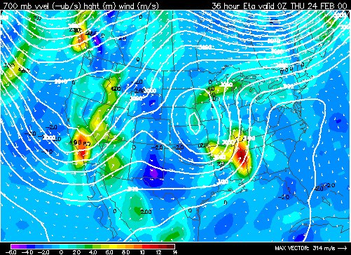
The image below is that of a negatively tilted trough located across the Southeast U.S. Notice the trough tilts from the NW to the SE and wind speeds are highest within the negative tilt.


is it purely that the isobars are curving to the SE, but are relatively "straight" across the NW side of the LOW  ?

therefore is there another less intense one over california ( in the SW) ?

I'm also trying to visualise this, particularly from a side on (cross-section) perspective

cheers
Dave


« Last Edit: 07 January 2007, 12:50:49 PM by Dave Nelson »

Offline Jimmy Deguara

  • Australian and Tornado Alley storm chaser
  • Administrator
  • Wedge tornado F5
  • *
  • Posts: 2,218
  • Gender: Male
  • Storm Chaser since 1993, Tornado Alley 2001
    • Australia Severe Weather
Re: Troughs
« Reply #1 on: 07 January 2007, 03:57:22 PM »
Hi John and Dave,

Thanks John for your part of the explanation.

Dave, it is an important question you have asked here. However, you are entering into an intricate and complex component of meterology and severe weather. Rather than go through a detailed explanation as to reasoning, it is probably sufficient to go through identification examples of upper troughs firts rather than the underlying principals. It is a bit like trying to understand tornadogenesis whereby really what you require are the basics perhaps rule of thumbs.

Of course, given I have limited time at this point, I hope  someone else could spend some time developing sufficient resources to cover the basics and then move on from there. Use of diagrams would be helpful and perhaps case studies.

Regards,

Jimmy Deguara
-------------------------------------
Australian Severe Weather
www.australiasevereweather.com

Australian Thunderbolt Tours
www.thunderbolttours.com

Phone  0408 020468  (International :  61  2  408 020468)

Offline Mike

  • Australian Severe Weather Moderators
  • Wedge tornado F5
  • *
  • Posts: 1,348
  • Gender: Male
  • Dry season here...boring!
    • http://StormscapesDarwin.com
Re: Troughs
« Reply #2 on: 11 January 2007, 08:22:25 AM »
Hi all, here's my bit to add to the question of troughs.  This is from a mate who is a meteorology major in Oklahoma who says (perhaps pertaining to their climate)...:

Upper surface troughs are related...in the mid-latitudes, they typically tilt with height to the west.  By surface trough do you mean a surface low pressure area or frontal trough?

A front can exist without the presence of an upper vorticity maximum...such as when a cold front propagates like a density current or like cold outflow for example, except on a larger scale.

Upper troughs are favourable for convection because they often cool the upper levels and increase instability, however surface troughs help insulate storms by inducing surface convergence.  However, there are may other thermodynamic factors that usually need to be present.

a negatively tilted trough is when the trough axis tilts upstream in the poleward direction and a positively tilted trough has a trough axis that tilts downstream in the poleward direction.  While both can be favourable conditions for supercells* positively tilted troughs result in increased directional shear and more favourable hodographs for tornadoes*


Strewth, I hope that answers it for you Dave!

Mike
Darwin, Northern Territory.
StormscapesDarwin.com
Lightning Research 2010/14