Author Topic: Armidale Hailstorm and NSW Tornadoes 29th September 1996  (Read 14827 times)

0 Members and 1 Guest are viewing this topic.

Offline Jimmy Deguara

  • Australian and Tornado Alley storm chaser
  • Administrator
  • Wedge tornado F5
  • *
  • Posts: 2,218
  • Gender: Male
  • Storm Chaser since 1993, Tornado Alley 2001
    • Australia Severe Weather
Armidale Hailstorm and NSW Tornadoes 29th September 1996
« on: 04 September 2007, 10:25:18 AM »
Hi,

I just had a conversation with a teacher at my school and I was shocked to discover that the supercell passing through there - basically The Armidale School and the Armidale University of New England experienced hailstones he believes were of the order of 5 inches in diameter - he was there at the time and he is reliable source being a science teacher. He suggested obviously many livestock were lost mainly sheep on the University. In one instance, a female student on the university was knocked down with a split head after trying to move her car. One of the car had a hailstone punching through the back window and removed the front window clean due to the giant wind assisted hailstone. I think it is investigation time - time to revisit.

For those that did not know, the insurance damage from this hailstorm amounted to 100 million dollars from memory - not bad for not such a major township.

This is a link to the initial report Michael placed on the website in the early edition of Storm News!

http://australiasevereweather.com/storm_news/1996/docs/9609-04.htm

Regards,

Jimmy Deguara
« Last Edit: 04 September 2007, 10:39:13 AM by Jimmy Deguara »
-------------------------------------
Australian Severe Weather
www.australiasevereweather.com

Australian Thunderbolt Tours
www.thunderbolttours.com

Phone  0408 020468  (International :  61  2  408 020468)

Michael Thomas

  • Guest
RE: Armidale Hailstorm and NSW Tornadoes 29th September 1996
« Reply #1 on: 20 September 2007, 07:27:31 AM »
Amazing stuff, 5 inches (12-13 cm) is huge. I think the 29th of September 1996 was probably the most amazing storm outbreak in Australia. Its a pity there is not more information out there on what happened that day. Certainly there was a deep surface low, I seem to remember having a look at the reanalysis to get an idea of what the wind shear was like that day but I forget the details. From memory I think the reanalysis had 40 knot low level jet. With such a deep surface low, shear would certainly have been impressive. Also, other that the Armidale hailstorm, several tornadoes were reported that day. Certainly a rare event.

Is there radar images of any of the storms that day or any other kind of information available?

Offline Michael Bath

  • storm chaser
  • Administrator
  • Wedge tornado F5
  • *
  • Posts: 1,602
  • Gender: Male
    • Australian Severe Weather
RE: Armidale Hailstorm and NSW Tornadoes 29th September 1996
« Reply #2 on: 20 September 2007, 07:38:01 AM »
Yes - have a look at the other articles written by Jimmy Deguara for that date - I included charts and satpics in some

Tornadic Outbreak

Tornado at Bearbung near Gilgandra

Tornado at Bundella

The first web radar was only available from 1998. I'll see what else I can find.

MB

Location: Mcleans Ridges, NSW Northern Rivers
Australian Severe Weather:   http://australiasevereweather.com/
Lightning Photography:   http://www.lightningphotography.com/
Early Warning Network: http://www.ewn.com.au
Contact: Michael Bath

Offline Jimmy Deguara

  • Australian and Tornado Alley storm chaser
  • Administrator
  • Wedge tornado F5
  • *
  • Posts: 2,218
  • Gender: Male
  • Storm Chaser since 1993, Tornado Alley 2001
    • Australia Severe Weather
RE: Armidale Hailstorm and NSW Tornadoes 29th September 1996
« Reply #3 on: 20 September 2007, 02:32:46 PM »
Michael and Michael,

I have yet to confirm any further evidence of these size hailstones. I was told that the storm began from Glen Innes and headed to Armidale by this same person. Given the profile on this day, this is a puzzling trajectory - I guess a sharp right mover could do it and they are known be giant hail producers.

Anyway, I have asked questions from the associated affected institutions - we'll see what comes of it.

Regards,

Jimmy Deguara
-------------------------------------
Australian Severe Weather
www.australiasevereweather.com

Australian Thunderbolt Tours
www.thunderbolttours.com

Phone  0408 020468  (International :  61  2  408 020468)

Offline Michael Bath

  • storm chaser
  • Administrator
  • Wedge tornado F5
  • *
  • Posts: 1,602
  • Gender: Male
    • Australian Severe Weather
RE: Armidale Hailstorm and NSW Tornadoes 29th September 1996
« Reply #4 on: 21 September 2007, 08:22:31 AM »
From the soundings it would appear right moving supercells heading south were possible. The shear profile on the attached soundings is pretty incredible for Australia - particularly the low level winds. Really goes to show how unusual this setup was.


Click images for full sized view:

Charleville

Brisbane

Cobar

Wagga


MB
« Last Edit: 25 September 2007, 03:35:14 AM by Michael Bath »
Location: Mcleans Ridges, NSW Northern Rivers
Australian Severe Weather:   http://australiasevereweather.com/
Lightning Photography:   http://www.lightningphotography.com/
Early Warning Network: http://www.ewn.com.au
Contact: Michael Bath

Offline Jimmy Deguara

  • Australian and Tornado Alley storm chaser
  • Administrator
  • Wedge tornado F5
  • *
  • Posts: 2,218
  • Gender: Male
  • Storm Chaser since 1993, Tornado Alley 2001
    • Australia Severe Weather
RE: Armidale Hailstorm and NSW Tornadoes 29th September 1996
« Reply #5 on: 21 September 2007, 10:11:18 AM »
Michael,

Which sounding or bits of information that lead yu to believe that right movers moving "sharply" right ie direct S to almost SSW according to the claims of this person? I never doubted there were right and left movers but I think nothing should have gone more than NE to SE in my opinion.

Regards,

Jimmy Deguara
-------------------------------------
Australian Severe Weather
www.australiasevereweather.com

Australian Thunderbolt Tours
www.thunderbolttours.com

Phone  0408 020468  (International :  61  2  408 020468)

Offline Michael Bath

  • storm chaser
  • Administrator
  • Wedge tornado F5
  • *
  • Posts: 1,602
  • Gender: Male
    • Australian Severe Weather
RE: Armidale Hailstorm and NSW Tornadoes 29th September 1996
« Reply #6 on: 21 September 2007, 11:11:58 AM »
Not SWW - just S. Any of those soundings show the potential and also Williamtown and Brisbane ones. Overall steering towards the SE.

Maybe the reference is 'from the Glen Innes area or direction'. Though looking at the map, GI is only 10km east of Armidale's longitude so no need to be considering SSW. 

If you have a storm cell affecting an area of 10s of ks wide it's not hard to see that it could have moved towards the SSE and still affected both towns. Downstream rain in GI and the core hitting Armidale.

The Armidale cell developed well east and in an isolated position relative to the line of activity that formed further inland - WV image at 4pm:


Regardless of whether it's possible for one to go that direction, it is a different observation to that of Peter Burr who wrote the original Armidale Hailstorm report.

MB
« Last Edit: 25 September 2007, 03:26:19 AM by Michael Bath »
Location: Mcleans Ridges, NSW Northern Rivers
Australian Severe Weather:   http://australiasevereweather.com/
Lightning Photography:   http://www.lightningphotography.com/
Early Warning Network: http://www.ewn.com.au
Contact: Michael Bath

Michael Thomas

  • Guest
RE: Armidale Hailstorm and NSW Tornadoes 29th September 1996
« Reply #7 on: 21 September 2007, 11:43:06 AM »
Looking at soundings quite useful. Very strong shear to say the least. I think the following soundings are also useful.

The morning sounding for Williamtown on the 29th-
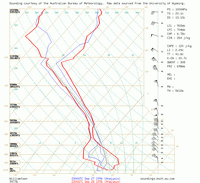

The morning sounding for Williamtown on the 30th-
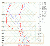

The morning sounding for Rockhampton on the 30th-
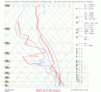

The morning sounding for Williamtown on the 29th shows quite a large elevated mixed layer with a dry adiabatic lapse rate extending from 850 to 650 hPa. The following day the William town shows 100 knots at 500 hPa, a very strong mid level jet. Finally, just for interests sake, the morning sounding for Rockhampton on the 30th shows about 1000 j/kg of CAPE and 60 knot mid level flow. I think not only the severity of this outbreak is amazing but also the coverage.

That satellite image really shows a nice isolated storm there. It would be interesting to know the distance travelled, duration and direction. If only there was radar data available.


MB edit - soundings now linked from local server.


« Last Edit: 25 September 2007, 03:38:35 AM by Michael Bath »

Offline Jimmy Deguara

  • Australian and Tornado Alley storm chaser
  • Administrator
  • Wedge tornado F5
  • *
  • Posts: 2,218
  • Gender: Male
  • Storm Chaser since 1993, Tornado Alley 2001
    • Australia Severe Weather
RE: Armidale Hailstorm and NSW Tornadoes 29th September 1996
« Reply #8 on: 21 September 2007, 03:05:05 PM »
Michael,

I tend to agree. The hodographs would not even allow for a typical southerly direction - Glen Innes is not the region I would have suspected it came from or even nearby. This person argued the point it came from Glen Innes and that is my point. Perhaps he meant Inverell?

Anyway, a very impressive event. My points above by the way is that when I know particular bits of information are suspect, then I begin to question the validity or the confidence of other information such as the hail size mentioned.

Quote
Regardless of whether it's possible for one to go that direction, it is a different observation to that of Peter Burr who wrote the original Armidale Hailstorm report.

Can you please suggest what was said in this report?

Regards,

Jimmy Deguara
-------------------------------------
Australian Severe Weather
www.australiasevereweather.com

Australian Thunderbolt Tours
www.thunderbolttours.com

Phone  0408 020468  (International :  61  2  408 020468)

Offline Michael Bath

  • storm chaser
  • Administrator
  • Wedge tornado F5
  • *
  • Posts: 1,602
  • Gender: Male
    • Australian Severe Weather
RE: Armidale Hailstorm and NSW Tornadoes 29th September 1996
« Reply #9 on: 22 September 2007, 01:26:02 AM »
Yes - after thinking about whether south moving cells were possible I checked the report linked to above:

"By lunch time the sky became darker with cumulonimbus clouds building in the west, and the familiar but ominous sound of rumbling thunder was heard in the distance. A storm arrived just before 2pm with rain and small hailstones - around 10 millimetres diameter. The rain stopped at 2.30pm but thunder continued to rumble intermittently. "

"Then at 3pm it approached from the south-west - a dark menacing cloud with an unusual colour. ....... "

Peter Burr's report

The Moree radar images would be available from the BoM if someone wants to contact them.

regards, Michael


Location: Mcleans Ridges, NSW Northern Rivers
Australian Severe Weather:   http://australiasevereweather.com/
Lightning Photography:   http://www.lightningphotography.com/
Early Warning Network: http://www.ewn.com.au
Contact: Michael Bath

Offline Jimmy Deguara

  • Australian and Tornado Alley storm chaser
  • Administrator
  • Wedge tornado F5
  • *
  • Posts: 2,218
  • Gender: Male
  • Storm Chaser since 1993, Tornado Alley 2001
    • Australia Severe Weather
RE: Armidale Hailstorm and NSW Tornadoes 29th September 1996
« Reply #10 on: 22 September 2007, 01:49:38 AM »
Don't get me wrong, this person is pretty bright as a science teacher but I think given the complex nature of storm development and motions, I have seen many people confused. He told me it was tracked from Glen Innes - but by whom? One of the SES guys? I don't think this component of the report is credible and it makes me lose a little confidence in the hail size report though I am not at all doubting at this point.

Regards,

Jimmy Deguara
« Last Edit: 25 September 2007, 01:34:50 PM by Jimmy Deguara »
-------------------------------------
Australian Severe Weather
www.australiasevereweather.com

Australian Thunderbolt Tours
www.thunderbolttours.com

Phone  0408 020468  (International :  61  2  408 020468)

Offline David C

  • Global Moderator
  • Barrel tornado F4
  • *
  • Posts: 643
  • Gender: Male
    • Thunderbolt Tours Storm Chasing Adventures
RE: Armidale Hailstorm and NSW Tornadoes 29th September 1996
« Reply #11 on: 22 September 2007, 04:02:31 AM »
I remember we looked at this event using the GFS archive some time back. This was a very progressive system and we have to be careful picking out soundings across a wide geographic are at particular times, given that the main activity erupted early during the afternoon. From memory I would have expect tornadic storms to move generally NE in this situation and I would assume that the Armidale storm to have been one of those that produced one of the tornadoes further to the SW over the northern central west slopes & plains.
Storm Chaser,
Thunderbolt Tours - USA & Australia Storm Chase Tours
www.thunderbolttours.com

Offline David C

  • Global Moderator
  • Barrel tornado F4
  • *
  • Posts: 643
  • Gender: Male
    • Thunderbolt Tours Storm Chasing Adventures
RE: Armidale Hailstorm and NSW Tornadoes 29th September 1996
« Reply #12 on: 22 September 2007, 04:39:45 AM »
Knock yourselves out if you have some spare time; you'll have to render the progression of the system in between the 6 hourly plots in your head, suffice it to say between 0 and 6z was prime time  :)
« Last Edit: 22 September 2007, 08:56:53 AM by Jimmy Deguara »
Storm Chaser,
Thunderbolt Tours - USA & Australia Storm Chase Tours
www.thunderbolttours.com

Offline Michael Bath

  • storm chaser
  • Administrator
  • Wedge tornado F5
  • *
  • Posts: 1,602
  • Gender: Male
    • Australian Severe Weather
RE: Armidale Hailstorm and NSW Tornadoes 29th September 1996
« Reply #13 on: 22 September 2007, 08:20:53 AM »
David - I already had all these plotted for 00z and 06z, just hadn't uploaded the links till right now.

What do you mean by a progressive system, are why are the 00z soundings on the 29th not indicative of the environment given storms occurred either side of that time?


GFS runs

29/09/1996 00z

Instability: Lifted Index

Relative Humidity: 0300 / 0500 / 0600 / 0700 / 0850 / 1000

Temperature: 0300 / 0500 / 07000850 / 1000

Winds (knots): 0300 / 0500 / 0600 / 0700 / 0850 / 0925 / 1000


29/09/1996 06z

Instability: Lifted Index

Relative Humidity: 0300 / 0500 / 0600 / 0700 / 0850 / 1000

Temperature: 0300 / 0500 / 07000850 / 1000

Winds (knots): 0300 / 0500 / 0600 / 0700 / 0850 / 0925 / 1000


Location: Mcleans Ridges, NSW Northern Rivers
Australian Severe Weather:   http://australiasevereweather.com/
Lightning Photography:   http://www.lightningphotography.com/
Early Warning Network: http://www.ewn.com.au
Contact: Michael Bath

Offline David C

  • Global Moderator
  • Barrel tornado F4
  • *
  • Posts: 643
  • Gender: Male
    • Thunderbolt Tours Storm Chasing Adventures
RE: Armidale Hailstorm and NSW Tornadoes 29th September 1996
« Reply #14 on: 22 September 2007, 01:24:21 PM »
David - I already had all these plotted for 00z and 06z, just hadn't uploaded the links till right now.

What do you mean by a progressive system, are why are the 00z soundings on the 29th not indicative of the environment given storms occurred either side of that time?

Hi Michael, as in rapid easterly progress of the low (not as in "progressive trough", if that's where the confusion was since this was a cut-off upper level low). In this respect I guess my memory is failing looking at the 0z and 6z data you posted, or I could easily be confusing it with the Bucca, Bulahdelah, Ben Lomond, or Merimbula charts, since we did look at several events where a more narrow window of severe weather existed -- might be Bucca, someone might plot them all :).

The point I am making is that one always has to be cautious about predicting storm motions from wind barbs of sounding data from particular sites at particular times when an overall storm system is moving rapidly. There as there was some talk of ssw tracking right-movers above, based on the soundings I presumed, and also of a teacher suggesting a storm moved from Glen Inned to Armidale). Looking at the reanalysis data you would imagine sustained left-movers heading generally ENE to NE and right-movers struggling SE which is consistent with the Armidale storm moving in from the south west.

Those charts all looks a little different to what GFS has in store for the 29th September 2007 :(
Storm Chaser,
Thunderbolt Tours - USA & Australia Storm Chase Tours
www.thunderbolttours.com