and Chasing
[Index][Archives]
Sydney Hailstorm: Wednesday 14th April 1999
by Michael Bath
| Storm News and Chasing [Index][Archives] |
Sydney Hailstorm: Wednesday 14th April 1999 by Michael Bath |
By late morning small cumulus had developed in a line from the far SW and towards the coast south of Sydney. By early afternoon some of these were growing and developing into congestus, others were starting to spread out as altocumulus - not usually a good sign for thunderstorm development. One or two of the larger clouds actually glaciated but with very low tops, probably no more than 4-5,000 metres but these were persisting somewhat (something I had observed a few times in the past, but I did not make the connection at the time). Altocumulus began to dominate and it became mostly cloudy during the middle of the afternoon. The only sign that something may occur later was more crisp cumulus congestus way to the south, just visible under the altocumulus in Sydney.
Close to the time I was leaving work at Parramatta (~4pm), it became apparent that the congestus to the far south was certainly looking promising and worth keeping an eye on. I suspected that some storms would probably only get going very close to the coast south of Sydney and then remain out to sea, but perhaps a lightning show would result.
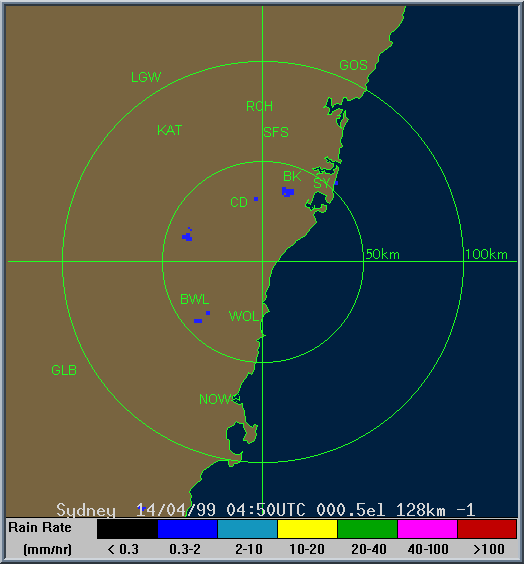
Around 5pm as I was arriving home I could see that a thunderstorm was gathering strength about 80km to my SSE. Having a good feel for locations/distance of storms I made a mental note that it appeared to be over land in the southern Wollongong area, and would most likely just move offshore and that would be it. The tower had a very strong verticle appearance (on the NW flank that I could see) indicating a very strong updraft and the potential for severe weather. I wanted to check the radar straight away to give me an indication of any other development and to determine the direction of movement of the storm. But, for whatever reason (news/dinner) I didn't until 6.40pm after briefly speaking with Jimmy Deguara (who said he was going out to a meeting, but to keep an eye on the situation). Lightning could now be seen about 50km to my SE at this stage. I obtained the latest Sydney radar loop covering the period 5.30 to 6.30pm local time and received my email. A message from Michael Thompson on the aussie-weather mailing list reported that a severe storm had just been through his area at Shellharbour and that golf ball sized hail was reported to the local radio station. He said the storm looked very severe with lowerings almost to the ground. The system was back building dramatically on its NW flank as the storm edged over the coast, indicating that it could clip the coast again to the north - over Sydney's southern suburbs. In a separate email (not sent to the mailing list), Michael also relayed that he had phoned the Bureau of Meteorology at 6pm to report the storm, only to be greeted with scepticism of the report. Obviously he was dismissed as an unreliable spotter as no severe thunderstorm Advice or Warning was issued (although one was belatedly issued at 10.20pm).
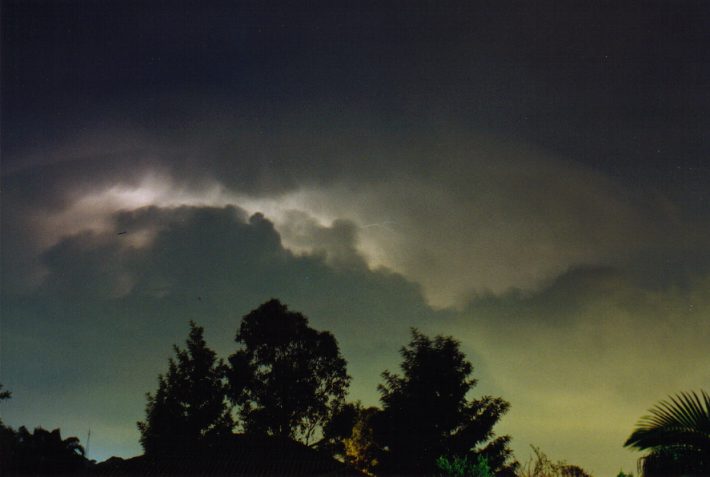
By 7pm it was obvious on both radar and visually (my home is about 40km from the coast) that the storm was moving directly NNE and heading straight into the southern Sydney suburbs. In fact by 7pm there was already maximum reflectivity on the radar, and the storm was over the Royal National Park heading towards Botany Bay and the Airport. Lightning was frequent to my SE but it seemed that a dead cell or other cloud was to the west of the storm, blocking the view of any lightning bolts. I could however see the glowing outline of the storm tops and reflections around the rest of the sky. Visually it continued like this until 8pm though was now much closer and bigger. Radar showed the most intense part of the storm was right over the eastern suburbs and city and would have been smashing these areas with hail officially measured to 9cm diameter, with larger stones probable. Just after 8pm the storm became much more spectacular from my vantage point to its west - continuous cloud to cloud lightning, cloud to air, and cloud to ground, though I could only see the top half of these. It coincided with a rapid propagation and development to the NW of the main thunderstorm making the whole structure visible with each lightning flash. With a boiling rear flank, rock solid backshearing anvil punching well through the tropopause, and the continuous lightning, I soon came to realise this was no ordinary storm. In fact it looked like the western flank of a supercell thunderstorm. After spending some time taking lightning photographs I made the remark to the 'list' that I thought it was a supercell and wondered what damage would have/was occurring in the most densely populated parts of Sydney.
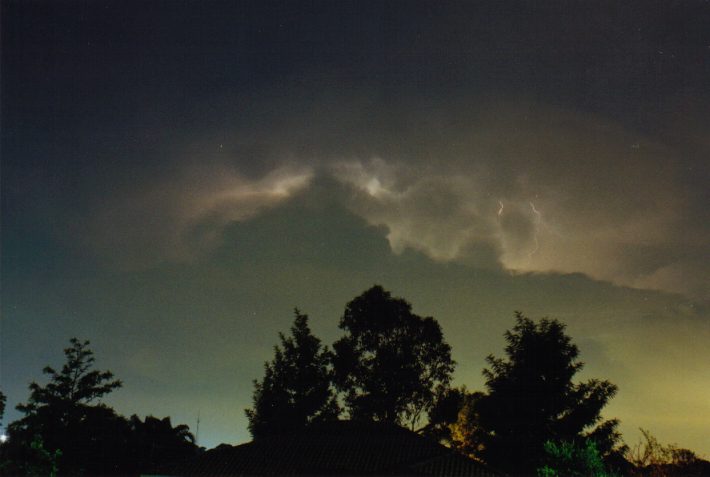
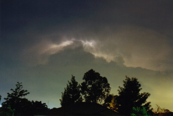
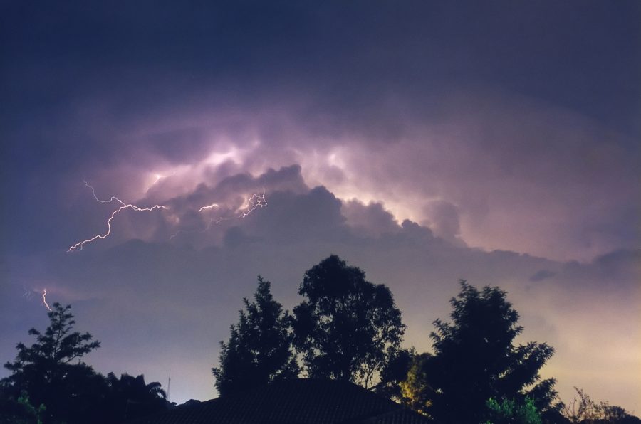
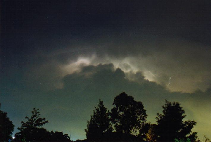
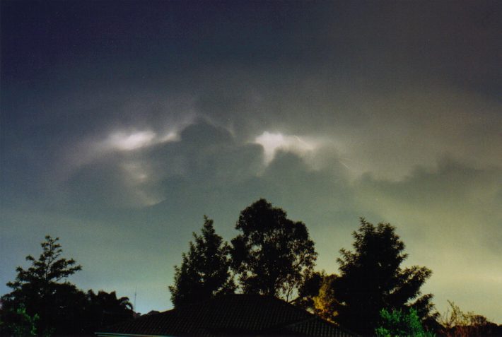
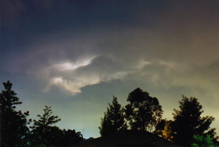
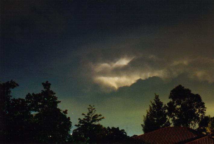
A sequence taken from about 8.15pm.
Towards 9pm, fresh southeast winds spread in with a layer of stratocumulus, blocking the storm as it edged out over the northern beaches. At about the same time the first reports of giant hail began to filter in and the discussions on the net got quite excited. Also at this time, another storm with hail passed through the eastern suburbs on a similar track to the supercell.
Later (between 10 and 11pm) a storm with some intense CGs spread through the western suburbs dumping some heavy rain but no hail. Brief blackouts occurred including at my place at 11pm.
 This is an aerial view of some of the major roof damage.
This photo is courtesy of Buchanan Reed.
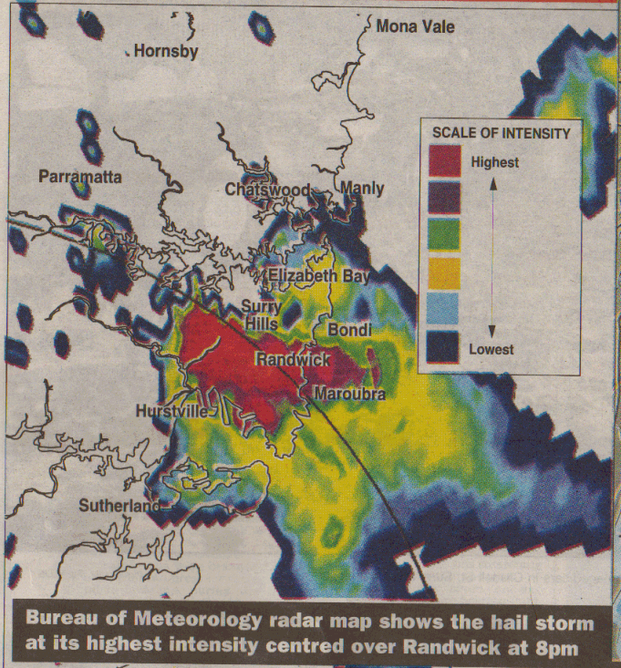
It wasn't until the next day that the analysis of the days observations and the radar clearly showed the significance of the event. The radar patterns were classic supercell from about 6.30pm onwards with a clearly defined V-notch most of the time. A hook echo was most prominent when the storm was right over the eastern suburbs, though no damaging winds were experienced there. Imagine if a large tornado had touched down as well! The storm tracked in the same direction as the Yamba to Ballina supercell of 18th December 1998 (NNE), and was well defined for almost 4 hours. Contrary to some early reports, there was no cell splitting or another storm suddenly developing closer to Sydney - the one storm cell just propagated on its NW flank continuously. The early afternoon observation of persisting low topped glaciated cells, has preceded supercell development on other occasions too, most notably the day that a tornado occurred at Shellharbour on 23rd March 1997.
As at 11th May, the total insured damages bill is in excess of AUD$1.4 billion, now making it the most costly natural disaster in Australian history, surpassing the Newcastle earthquake (1989) and Tropical Cyclone Tracy in Darwin (1974).
Although the time of year and the area affected by the storm is unusual for a supercell, many hailstorms with simlilar sized hail (but officially recorded hail sizes slightly smaller than this event) have occurred in Sydney, even in recent years. Most notably, the supercell hailstorm of Sunday 18th March 1990 affecting the western suburbs, and the supercell of Monday 21st January 1991 affecting the northern suburbs. However, insured loses for these two events are far lower than for the current event.
A zoomed in view of the image above, while the supercell was over the eastern suburbs at 8pm can be viewed here.
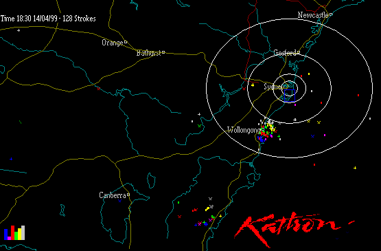
The radar imagery are courtesy of the Bureau of Meteorology.
The colour bars on the images represent % of strokes in 10 minute intervals from the time shown (top left of each image), starting with gray. Each screen is 1 hour. This gives an indication of storm building, steady or decline.
Click the image for access to a sequence from 4.30pm 14/4 to 1.30am 15/4 (local time).
GMS-5 Satpic loop from 4.30pm 14th to 4.30am 15th (local time). These images are sourced from Naval Pacific Meteorology and Oceanography Center
by James Crouch, Rushcutters Bay.
I had about two minutes warning - you could hear a distant roar - I didn't know what it was at first - and it just got louder and louder. It was about 7:35pm.
Things started breaking as soon as the first isolated hail stones began falling, neighbours windows, roof tiles, that sort of thing. The roar was quite loud, but still distant, for a moment it sounded like "things" were falling out of the sky and I actually feared for a few seconds that it was debris, not ice!!
Anyway, the tiles on my roof were taking a pounding, ceiling plaster was flaking off all over (I guess a combination of hail and tile impacts). There was nothing I could do, and I didn't have a view, so I went down to the street and sat with a few neighbours and watched as 2.5 inch hailstones slammed into the footpath. I couldn't see much in the way of cloud but there was lightning every 2-3 seconds. The Bayswater Rd was empty, and covered in a 2 inch layer of ice (ice was still piled up in corners 3 hours later).
The heaviest hail lasted about 10-15 minutes and then it rained (showered, whatever) until 2ish. That was the killer. I drilled a few holes in my ceiling where it was sagging the worst (and until I ran out of pots and pans) and then checked my neighbours. I wasn't the worst, the girl across the landing was. She had a 2-3lt/min flow from the light in her kitchen for a while, and sundry other leaks of various flow rates. (I climbed up into the ceiling,... there are at least 300 tiles shattered or cracked, you could see the sky through all over the place.)
Then, once they'd isolated her power and we'd drilled holes in other peoples ceilings, I went and checked my car. It's a Daihatsu Feroza. The bonnet is trashed - 20 odd (4-5cm dents) and one of the rear side windows was completely smashed - with a bit of resultant water damage. Not so bad, I haven't got onto AAMI yet so I have no idea when it'll have a chance to get fixed up. Mean time I guess that I'm up for driving on storm chases!
Had a pleasant night's sleep on cushions in the hallway, that was the only place that didn't have leaks!! I wonder if they've fixed the roof yet, anyone seen a forecast for tonight?....
If you have ANY photographs or video of the damage, the hail, lightning, the storm and so on,
please email Jimmy Deguara.
|
Document: 9904-01.html
Updated: 14th April, 2004 |
[Australian Severe Weather index] [Copyright Notice] [Email Contacts] [Search This Site] |