[Index]
Tropical Cyclone INNIS
[Australian Region][South Indian Ocean][South Pacific Ocean][Southern Hemisphere][Summaries and Track Data]
| Tropical
Cyclones
[Index] |
Tropical Cyclone INNIS [Australian Region][South Indian Ocean][South Pacific Ocean][Southern Hemisphere][Summaries and Track Data] |

WTPS01 NFFN 170600
Gale Warning 026 ISSUED FROM RSMC NADI Feb 17/0717 UTC 2009 UTC.

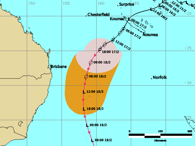
Tropical Cyclone INNIS 10F [995hPa] centre was located near 21
decimal 8 South 163 decimal 9 East at 170600 UTC.
Position Poor.
Repeat position 21.8S 163.9E at 170600 UTC.
Cyclone moving south-southwest at about 13 knots.
Expect sustained winds of 35 knots close to the centre, increasing to
40 knots during the next 6 to 12 hours.
Expect winds over 33 knots within 200 nautical miles of centre in the
southern quadrant and within 120 nautical miles elsewhere of centre.

Forecast position near 24.5S 162.4E at 171800 UTC.
              and near 27.9S 160.1E at 180600 UTC.

All vessels  within 300 nautical miles of centre are requested to
send
reports every three hours. VOS reporting ships use normal channels.
Other vessels fax plus 679 6720190 or email naditcc at met dot gov
dot fj.

This warning cancels and replaces warning 025.
=========================================================================
WTPS01 NFFN 171200
Gale Warning 027 ISSUED FROM RSMC NADI Feb 17/1316 UTC 2009 UTC.

Tropical Cyclone INNIS 10F [990hPa] centre was located near 22
decimal 9 South 163 decimal 7 East at 171200 UTC.
Position Poor.
Repeat position 22.9S 163.7E at 171200 UTC.
Cyclone moving south-southwest at about 13 knots.
Expect sustained winds of 40 knots close to the centre.
Expect winds over 33 knots within 150 nautical miles of centre in the
southern semicircle and within 120 nautical miles of centre in the
northern semicircle.

Forecast position near 26.2S 163.1E at 180000 UTC.
              and near 29.9S 161.7E at 181200 UTC.

All vessels  within 300 nautical miles of centre are requested to
send
reports every three hours. VOS reporting ships use normal channels.
Other vessels fax plus 679 6720190 or email naditcc at met dot gov
dot fj.

This warning cancels and replaces warning 026.
=========================================================================
WTPS01 NFFN 171800 CCA
Gale Warning 028 ISSUED FROM RSMC NADI Feb 17/1940 UTC 2009 UTC.

CORRECTION TO CENTRAL PRESSURE...
Tropical Cyclone INNIS 10F [995hPa] centre was re-located near 24
decimal 8 South 160 decimal 5 East at 171800 UTC.
Position Poor.
Repeat position 24.8S 160.5E at 171800 UTC.
Cyclone moving southwest at about 18 knots.
Expect sustained winds of 35 knots close to the centre.
Expect winds over 33 knots within 150 nautical miles of centre in the
southern semicircle and within 120 nautical miles of centre in the
northern semicircle.

Forecast position near 28.8S 158.8E at 180600 UTC.
              and near 33.4S 158.5E at 181800 UTC.

All vessels  within 300 nautical miles of centre are requested to
send
reports every three hours. VOS reporting ships use normal channels.
Other vessels fax plus 679 6720190 or email naditcc at met dot gov
dot fj.

This warning cancels and replaces warning 027.
|
Document: innis.htm
Updated: 9th March 2009 |
[Australian Severe Weather index] [Copyright Notice] [Email Contacts] [Search This Site] |