[Index]
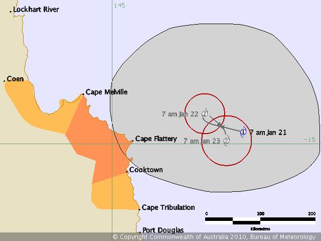
Tropical Cyclone NEVILLE
[Southern Hemisphere Summary][Summaries and Track Data]
| Tropical
Cyclones
[Index] |
Tropical Cyclone NEVILLE [Southern Hemisphere Summary][Summaries and Track Data] |

HIGH SEAS WEATHER WARNING FOR METAREA 10 ISSUED BY THE AUSTRALIAN BUREAU OF
METEOROLOGY, BRISBANE 1503 UTC 20 January 2010

GALE WARNING FOR NORTH EASTERN AREA

SITUATION
An deep tropical low, 998 hPa, is near stationary near 14.5S 147.0E.  Gales may
develop around this system during this morning.

AREA AFFECTED
Within 120nm of the centre on the western and northern sides.
FORECAST
Clockwise winds 30/33 knots, possibly reaching 34-40 knots during this morning.


REMARKS
All ships in the area please send weather reports every three hours.  Regular
weather observing ships use normal channels.  Other ships please use either
email to [email protected] or fax to +61732200221 or satellite to SAC 41
through Land Earth Station Perth 222.

WEATHER BRISBANE
=========================================================================
HIGH SEAS WEATHER WARNING FOR METAREA 10 ISSUED BY THE AUSTRALIAN BUREAU OF
METEOROLOGY, BRISBANE 1859 UTC 20 January 2010

GALE WARNING FOR NORTH EASTERN AREA

SITUATION
At 1800 UTC Tropical Cyclone Neville was centred within 30 nautical miles of
latitude fourteen decimal seven south [14.7S] longitude one hundred and forty
seven decimal three east [147.3E]
Recent movement : near stationary
Maximum winds   : 35 knots
Central pressure: 994 hPa
AREA AFFECTED

FORECAST
Southern Semicircle:
Maximum winds to 35 knots within 40 nautical miles of the centre, increasing to
45 knots by 1800 UTC 21 January.

Northern Semicircle:
Maximum winds to 35 knots within 80 nautical miles of the centre, increasing to
45 knots near the centre by 1800 UTC 21 January.


Forecast positions
At 0600 UTC 21 January: Within 40 nautical miles of 14.7 south 146.8 east
                        Central pressure 989 hPa.
At 1800 UTC 21 January: Within 55 nautical miles of 14.4 south 146.5 east
                        Central pressure 986 hPa.
REMARKS
All ships in the area please send weather reports every three hours. Regular
weather observing ships use normal channels. Other ships please use either email
to [email protected] or fax to +61732398776 or satellite to SAC 1241 through
Land Earth Station Perth 212.
Next warning will be issued by 0100 UTC 21 January 2010.
WEATHER BRISBANE
=========================================================================
HIGH SEAS WEATHER WARNING FOR METAREA 10 ISSUED BY THE AUSTRALIAN BUREAU OF
METEOROLOGY, BRISBANE 0147 UTC 21 January 2010

GALE WARNING FOR NORTH EASTERN AREA

SITUATION
At 0000 UTC Ex-Tropical Cyclone Neville was centred within 30 nautical miles of
latitude fourteen decimal seven south [14.7S] longitude one hundred and forty
seven decimal one east [147.1E]
Recent movement : near stationary
Maximum winds   : 30 knots
Central pressure: 997 hPa

Forecast position
At 1200 UTC 21 January: Within 60 nautical miles of 14.4 south 146.5 east
                        Central pressure 997 hPa.

AREA AFFECTED
Nil.

FORECAST
Winds are no longer expected to exceed 33 knots.

REMARKS

No further warnings will be issued unless the system reintensifies.
WEATHER BRISBANE
| [Australian Severe Weather index] [Copyright Notice] [Email Contacts] [Search This Site] [Privacy Policy] | |
| Document: tropical_cyclone_neville.htm | Updated: 17 March 2010 |